
 Tweet
Tweet
Is the Ponderosa Way road access to Codfish Creek open now? Some sites say it has been closed for several months for repairs to the road & bridge, but there?s no mention of any closure on the official web site.
-
-
I haven't tried going down that road since last year - when it was so rutted I would have bottomed out my SUV.
This page says the bridge/road is closed, but you could call them to see, I bet they'd let you know.
Oops, missed the link off the above page - looks like it is closed.Construction of this project began in early August of 2022 and is expected to be completed by summer of 2023. Throughout this project, Ponderosa Road will be closed to vehicle traffic near the State Park boundaries on the north and south siides of the canyon.
Last edited by ponderosa; 04-24-2023, 12:28 PM.
-
Well, there you go lol Thanks for the infoComment
-
Anyone ever go to Damascus? Last time I was there was maybe 1976 or 1977.
Was old townsite east of Big Reservoir/Morning-Star back in the 1800's. One of those 2000+ people town that popped up for a couple years and was abandoned when the miners moved to the next big strike.
Mid 1960's to mid 1970's we used to explore all over near Foresthill; there are dozens upon dozens of old mines that are not on the maps anymore, but were on the 1960's Forest Service maps...Comment
-
I'll dig the maps out; I couldn't find an online map of the area. I have my Dad's forest Service maps we used, most dating to 1960-1964. Those maps are nice; they're covered with mine sites/names that aren't on current maps. Dozens upon dozens of old mines.
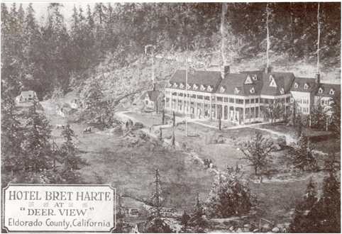
Deerview/Bret Harte Lodge is interesting to check out too; it's up off Mosquito Road between Wentworth Springs Road and the town of Mosquito (closer to Wentwrth Springs Road)
Comment


There are currently 3087 users online. 152 members and 2935 guests.
Most users ever online was 65,177 at 7:20 PM on 09-21-2024.


Comment